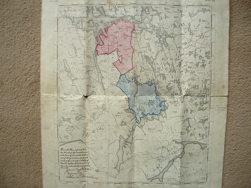
I recently found an old, linen-backed map of central Lewis, showing the Grimersta Estate. This stretches between Loch Roag (south of Great Bernera) and Loch Langabhat. The map was part of an arrangement between James Matheson and others over shooting and fishing rights on the estate. The map is annotated with coloured sections, stretching from the northern shores of Loch Langabhat, from Loch Coire Geurad to the current B8011 Uig road (marked in blue) and north from the road to the shores of Loch Barraglom, south of Great Bernera (marked in red). Other sections, demarkated in dotted blue, stretch from the Grimersta River westward, and include the island of Great Bernera.
The map itself is endorsed with the text:
This is the plan referred to in the Minute of Agreement annexed to the Lease of Grimersta shootings and fishings, dated twenty second, twenty sixth and twenty ninth days of November Eighteen hundred and seventy two and is subscribed by us of even date therewith.
Signed by James Matheson, Alex D. MacLeay and a signature I cannot decipher.
No comments:
Post a Comment