This blog will contain stories, which I have unearthed from the history of the Isle of Lewis. The period is from the late 19th century to the present day. Exceptions confirming the rule, of course. The stories will be copied from my other blogs, primarily Atlantic Lines, and others that I have sourced myself (many times with the aid of others) will be added. The focus will be strongly on the First World War.
The title? The Pentland Road is a single-track road that runs between Stornoway and the villages of Breasclete and Carloway. It was designed to be a light railway, which was to have transported fish from the quays at Breasclete and Carloway to the processing facilities in Stornoway. However, the designs did not progress beyond the stage of a trackbed. And it was not until the 1980s that a metalled road was put in place.
The Pentland Road is a historical roadway, and I hope to make this blog a conduit for what I have found out about this island's history. The below text is a blog entry dedicated to the road.
The Pentland Road is not very well known to non-islanders, and takes a bit of finding. Residents of Carloway and Breascleit use it as a shortcut into town; it's only 16 miles to Carloway along the Pentland Road, but as much as 26 along the main road through Leurbost and Callanish. Its origins go back to Lord Leverhulme's years of ownership of Lewis. As I mentioned in a previous article, he had contrived plans to industrialise the island, and one of the projects was to establish a fishery station at Carlabhagh / Carloway. Fishermen from the West Side would land their catches at the pier there, which would save them the trip round the Butt of Lewis to Stornoway. They would refuel at Carloway and set out again. Their catches would be transferred to Stornoway by railway.
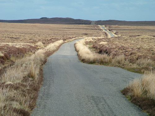
To find the Pentland Road in Stornoway, you need to follow the signs for the Council Dump at Bennadrove. Just after the garage, a broad road branches off to the left with big signs for Carlabhagh and Breascleit. After about half a mile, it leaves the houses of Marybank behind and heads out into the open moor. I have walked the length of the Pentland Road, all the way into Carloway in 4½ hours. That was pushing it a bit, as I had to catch a bus back to town from Carloway at 5 pm, and I didn't start until midday. It's a fascinating trip, particularly when travelling west, with great views. The road is level, because it was to be the trackbed for the railway. If my information is correct, a railway did exist at one time, out to the Marybank Quarry, starting at the Patent Slip in Stornoway. The Patent Slip no longer exists. It was the place where ships were launched, but these days the fuel depot and an engineering business are in its location.
The Carloway Railway never came into existence. Lord Leverhulme abandoned his industrial revolution for Lewis, because the Stornoway merchants were opposed to them. They saw those industries as competition and a threat to their businesses and interests. So, they agitated amongst the crofters with whom they traded, telling them that Leverhulme was out to get them off their land. With the Crofting Act barely 35 years in existence, and the memories of the land struggle of the 1880s still within living memory, they did rise up.
The Pentland Road was left as a dug out trackbed, barely passable in a motor vehicle. A branch was created to Breascleit Pier, where until very recently a small pharmaceutical plant operated. It was used for extracting a compound which was used in the treatment of cancer. Its uptake was limited, for the simple reason that its efficacy was not adequately proven. Nonetheless, the loss of 11 jobs is a blow for a small community like Breascleit. I am not aware that anyone has taken over the enterprise.
Along the Pentland Road are countless peatbeds. Peat is still used extensively for fuel in the island, but it's hard graft getting it. In April and May (when the picture in the above gallery was taken), people go out to cut the peats. The slabs you can see are quite heavy when they're freshly cut. They are left to dry, and you'd be surprised how dry they become, in spite of the climate. During the summer, they are bagged up and taken home. You need a license from CnES to cut peats, and if you buy a house in Lewis (even in Stornoway), there may be a peatbank allocated to you. The second branch from the Pentland Road, 4 miles west of Stornoway, leads to Achamor. The road reaches a height of nearly 500 feet above sealevel. The views are spectacular, as you head southwest. The hills of Lochs open out, with the dark slopes of Roineabhal set off against the backdrop of the distant Harris Hills. In winter, the latter may well be covered in snow.
Achamore is a singular village in Lewis, in that it is the only one not anywhere near salt water. It is about 5 miles from the sea. Plenty of fresh water lochs about though. Above Achamore rises the hill of Eitsal, on which transmitters for radio, TV and mobile telephony have been built. If I cannot see Eitsal, I don't have reception on the mobile, unless I'm in Stornoway. Before the transmitter was built, back in 1976, TV reception was poor. There was a transmitter somewhere in Sutherland. A Stornoway company had established a reception station at Bennadrove, from which the signal was fed into town by cable.
Back on the Pentland Road, it leads right up to Carloway Pier. This is still in use by fishermen. Barely. I once encountered a gentleman there who told me he was the sole fisherman left operating out of Carloway. I believe you can still refuel there. A barometer and thermometer is set in the wall of the building of the pier. The instruments are quite old, I believe more than a hundred years. They were paid for by girls from the island who had gone to the mainland to work, and had collected their savings to pay for the barometer, to help the fishermen to predict the weather.